
Cambridgeshire in the Viking Age

The map above shows the four main earthworks within Cambridgeshire, which lie along a conspicuous line of chalk uplands which corresponds to the Icknield Way.
At the time they were built, the chalk downs were the only clear track between Hertfordshire and Suffolk, passing through Cambridgeshire. On the north side, the low-lying river courses were impassable in many places, and the lack of adequate bridges made long-distance journeys by this route troublesome, if not impossible. To the south, the clay soil was heavily forested and overgrown, and so it was only along the crest of the ridge that travel was possible for merchants, general travellers, and armies.
Of the four major earthworks, the Devil's Dyke is the most notable, at 7.5 miles (12km) long. The dyke is still up to 15ft (5m) high in places, while the ditch in front of it (to the south west) is 17ft (6m) deep and up to 65ft (22m) wide, giving any attacker a formidable obstacle, especially when it is realised that the ditch and dyke have probably been mellowed by time. In addition, the dyke is constructed from topsoil from the immediate area, and not from the soil excavated from the ditch, so it is thought that a secondary outer bank was constructed from this, which later partially collapsed into the ditch and/or was removed.
None of the ditches and dykes have been dated exactly, but excavations have shown that the underlying soil contains Roman pottery and some coins from the third century AD, conclusively disproving the earlier theory that the earthworks were from the Iron Age, and so contemporary with the few hill forts in Cambridgeshire. However, there is nothing to date the works themselves, and although an extensive Saxon cemetery was found beside the Bran Ditch which contained burials on an east-west alignment and which were devoid of grave goods (suggesting Christian burial, and a late date), this cannot be tied to the construction of the ditch, and is likely to be much later.
At the Fleam Dyke, excavations in 1921 suggested that the original bank was increased in size on two occasions, with large gaps between the improvements, but produced no dateable evidence from the bank itself apart from Roman building materials from a building known to be nearby.
The most likely explanation is that the ditches and dykes were built over an extensive period, perhaps starting with the immediate post-Roman period when the Saxons & Angles began their long fight for a toehold in England, and given the location and axis of the dykes, it is a reasonable assumption that they were a defence erected by the East Angles against the Britons. Indeed, an interesting comparison can be drawn betweeen these dykes and the major earthworks of the early period in Denmark to protect against the Germanic tribes around the same period - the very area the Angles migrated from.
Given the evidence from the Fleam Dyke, it can be assumed that the defences were kept in good order for at least three hundred years, and may even have been in regular use well into the Viking period, defending against the expansion of Mercia.
Whatever the reason for the building of the dykes, their scale and state of preservation make them worth a trip. Standing on the highest part of the Devil's Dyke and looking down into the deepest part of the ditch gives a vivid impression of the strength of the defences, and although the country around the Dyke is now rolling farmland to the south and drained fens to the north, it is still possible to see how well sited it was at a time when the country looked very different.
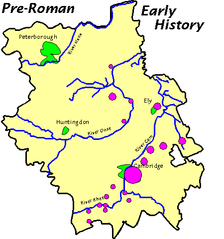
The Victoria History of the County of Cambridge and the Isle of Ely published in 1938 gives an introduction to the settlements in Cambridgeshire during the Stone, Bronze and Iron Ages by J. Grahame Clark, in which he states that settlement was restricted almost exclusively to the river courses and their gravel soil, while in the same publication T.C. Lethbridge asserts that "It would be an exaggeration to say that there are no fields in Cambridgeshire without pieces of Samian pottery on them, but there are so many where it is present that the remark can hardly be called absurd", and thus the Roman occupation covered all of the dry ground of the river plains and the clay plateaus, and even extended into the outlying areas of the fens where drainage work could improve the land.
With the end of the Roman period, settlement returned to the old pattern which followed the rivers, and only when growth demanded more space did settlement spread back onto the chalk hills. However, during the Viking period the Saxon system of landholding and tenure in the South, the Viking ways of the Danelaw combined to induce heavier use of the marginal land, and the clearance of forest to provide for more pasture and arable land. Combined with an increase in European trade, settlement appears to have been expansionary throughout the period of the ongoing strife over the borders of the Danelaw, and so perhaps the uncertainty and warfare, and the resulting damage to houses and crops, has been overplayed in this area.
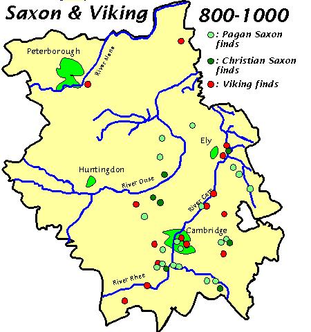
As the map makes clear, the influence of the Danes was not restricted to a few outposts or some chance finds of single objects - instead, the archaeological picture is of an integrated society, with people from both backgrounds mixed together (or at the very least, a people who were at home using the cultural items of both cultures).
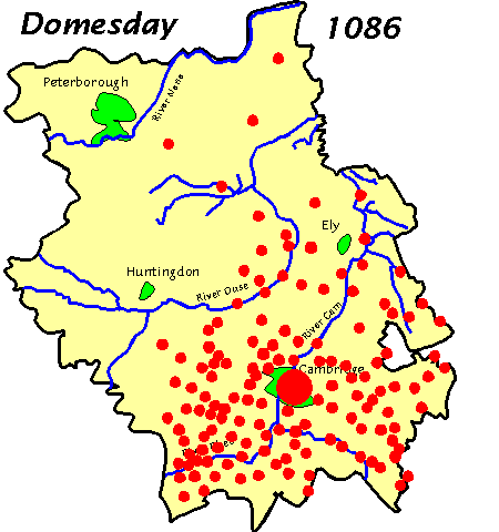
With the coming of the Normans, it is clear that settlement had been extended over almost all of the available area, as the Domesday Book records in some detail. The map below shows the villages and manors which appear in the Domesday records for Cambridgeshire - note that Huntingdonshire and Peterborough were recorded separately, and are not shown here.
The modern county of Cambridgeshire has subsumed Huntingdonshire on its western side, and gained the Soke of Peterborough to the north west from Northamptonshire, now representing a far greater area than it did in the time of the Saxon kings.
The largest land type by area in Cambridgeshire is Fen, either the Peat Fen of the central area formed over the last two thousand years from decaying vegetation, or Silt Fen, where the rivers and the sea keep the land permanently wet. Although the fens have mainly been drained now, some areas remain which are almost exactly the same as in the time of the Vikings, but not all of this land has always been fen - in Roman times, canals were built to drain the land, and for several hundred years the periphery of the fens was productive and supported farms, but with the departure of the Romans in the C5th, the canals were not maintained, and as a result they silted up or became blocked, and the land again became wet, and remained in this state until the large-scale drainage works of the C17th, when much of the fenland was reclaimed for farming.
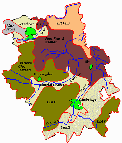
The map above shows the varying soil types found in the modern county of Cambridgeshire, the main modern settlement areas, and the major rivers in the county. The red outlines delimit the land types, and rivers are shown in blue.
Despite its reputation for being flat, Cambridgeshire does have some hills in the south of the county, where clay plateaus and a chalk ridge rise above the gravel soil of the river courses to a height of 150 metres in places. Along these runs the ancient Icknield Way, a road of sorts which dates from the Iron Age or before, and it is clear that it is only along this ridge that travel over any distance was possible without encountering the problems of river and stream, dense forest, fen and marsh which waited below. Other areas of high ground remain in the fenland, where once they stood as islands in a sea of marsh and reeds.